

 LinkBack URL
 About LinkBacks
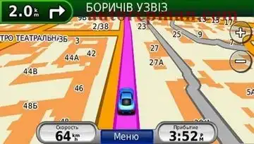
Aeroscan map of Ukraine (Aeroscan roads NT from 01.06.2010) [IMG] by HAWK25 TYP.
Has no analogues in Ukraine in all aspects of the use of the joint road map of Ukraine from the company "Aeroscan" includes all settlements of Ukraine, as well as 190 settlements with full address part, home 48,35% of the population. 22 made in real 3D view. Special attention of the users of our product attracts the most extensive database of points of interest - 120000, routing taking into account the wishes of the Ukrainian drivers, the study of the most visited places of the Crimea, the floor of which reached 50 settlements, the Carpathians, the Azov coast, other recreation areas.
For the full potential navigators Garmin, as well as more comfortable and accurate navigation in our map for the first time in Ukraine implemented features Lane Assist (which tells the driver the band, you need to take before performing rotation) and Point Addressing (navigating to addresses with letters, fractions and buildings). Thus, the company makes every effort to provide quality product since 2003. Teams of mappers and testers work in many corners of Ukraine and established relationship with the consumer helps us to respond effectively to changes in the road network, both in towns and on the highways of the country.
Attention! For correct operation of the devices is recommended properties to set the route for the minimum time.
Main features:
Road map of Ukraine contains detailed road network, including highways and unpaved roads in the regions, detailed mapping of roads and streets in the settlements with the status of not lower than "the settlement of urban type" (PTH), detailed junction throughout Ukraine with function autoprocedure route (city route is created taking into account the existing limit signs, road traffic (prohibition of turns, one-way movement, etc.) in scale 1:100000 (1 cm = 1 km) and plans 190 settlements in the scale of 1:10000 (1 cm = 100 m) with address search, and the names and boundaries of all settlements of Ukraine, railway network, hydrography and vegetation.
Map provides search addresses in support of house numbers and communication between all settlements of Ukraine. The road is divided in accordance with axial strips markup that provides routes with the correct maneuvers and approaches to the destination with corresponding hand movement. The building has a real form and numbering, if applicable. Constant updating maps on the tracks, adding interchanges, one-way streets, banned turns, speed limits, direction of movement and opportunities to travel. The information for the updates is going exclusively with the real situation on the roads of the country. Map tested in real conditions and improving every day
Total: 190 settlements with detailed road network and address search.
Release date: 2010
Version: 01.06.2010
Developer: Aeroscan
Platform: Garmin
Language: Ukrainian only
Size: 128.74 Mb
Download material for reference
Download material for reference
Welcome to the Auto Repair Manuals.
+ Reply to Thread
Results 1 to 1 of 1
Aeroscan map of Ukraine (Aeroscan roads NT from 01.06.2010) [IMG] by HAWK25 TYP
4 stars based on
1 reviews
-
15.06.2010 09:13 #1


- Join Date
- 01.01.2007
- Model
- ID4
- Posts
- 3,141
Aeroscan map of Ukraine (Aeroscan roads NT from 01.06.2010) [IMG] by HAWK25 TYP
 Reply With Quote
Similar Threads
-
TeleAtlas Major Roads of Europe 2010/2011 Blaupunkt DX Namely
By AutoMAN in forum Built-in car navigationReplies: 1Last Post: 28.06.2011, 13:57 -
Compiling maps of Ukraine for Garmin v. 3.5 from 20.06.2010 g. (by HAWK25) IMG unlock
By AutoMAN in forum GarminReplies: 1Last Post: 14.06.2011, 08:54 -
Map of Poland (GPMapa NT 2010.1 3d) [MapSource + IMG]
By AutoMAN in forum GarminReplies: 0Last Post: 24.06.2010, 08:14 -
Map of Russia (Garmin OpenStreetMap Russia from 08/06/2010)
By AutoMAN in forum GarminReplies: 1Last Post: 20.06.2010, 11:30 -
Compiling maps of Ukraine for Garmin v.3.4, 03.06.2010. (by HAWK25) IMG unlock
By AutoMAN in forum GarminReplies: 0Last Post: 15.06.2010, 09:53