

 LinkBack URL
 About LinkBacks
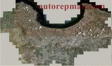
Satellite map of Algeria with the binding.
Imagine a satellite map of Algeria.
Show the downloaded area on the figure. It is the capital and the suburbs (approximately - Large Algeria).
Map is uploaded using SASPlanet with maps.google. A map is a satellite overlay hybrid (also google). Map uploaded with the scale of 250 m (approximation 16), 125 m (approximation 17, 18), 25 m (approximation 19, 20). That is uploaded approximation from 16 to 20. Closer on google no.
Uploaded cached photos stuck together in the form of files with the extension ecw. Each scale is one file + file with the extension map. Then to reduce the size of the files produced by the conversion in the expansion ozfx3. All but 20 of the approximation. It contains a Converter for some reason hangs. If the hand will be in demand, try to solve the problem.
The hand laid files and ecw and ozfx3. You have to download all the files is not necessary, select the desired format.
Extra info: Swinging all this to solve problems navigating the city.
Also provided demand will expand the downloaded area until the whole country (with cuts).
Download material for reference
Download material for reference
Welcome to the Auto Repair Manuals.
+ Reply to Thread
Results 1 to 1 of 1
Satellite map of Algeria with the binding
4 stars based on
1 reviews
-
24.06.2010 08:01 #1


- Join Date
- 01.01.2007
- Model
- ID4
- Posts
- 3,141
Satellite map of Algeria with the binding.
 Reply With Quote
Similar Threads
-
Map of Poland (GPMapa NT 2010.1 3d) [MapSource + IMG]
By AutoMAN in forum GarminReplies: 0Last Post: 24.06.2010, 08:14 -
Map of Russia (Garmin OpenStreetMap Russia from 08/06/2010)
By AutoMAN in forum GarminReplies: 1Last Post: 20.06.2010, 11:30 -
Walking map of Helsinki (Helsinki cityXplorer 2011.10) [IMG]
By AutoMAN in forum GarminReplies: 0Last Post: 15.06.2010, 10:00 -
Map of Nizhny Novgorod and region (ver. 20100603) [MapSource + IMG]
By AutoMAN in forum GarminReplies: 0Last Post: 15.06.2010, 09:22 -
Aeroscan map of Ukraine (Aeroscan roads NT from 01.06.2010) [IMG] by HAWK25 TYP
By AutoMAN in forum GarminReplies: 0Last Post: 15.06.2010, 09:13